



Routes
Kępno County/ Greater Poland Voivodeship
Showing 18 routes

65% Offroad score
Moderate
199m Highest peak
Borówno - Bolesławiec
Offroad score65%
No known restrictions81%
Distance30.09 km
Highest peak199m
Offroad19.7 km
1 year ago
View route
63% Offroad score
Moderate
197m Highest peak
Grębanin - Trębaczów
Offroad score63%
No known restrictions98%
Distance15.15 km
Highest peak197m
Offroad9.62 km
1 year ago
View route
69% Offroad score
Moderate
198m Highest peak
Oświęcim - Borek
Offroad score69%
No known restrictions97%
Distance70.99 km
Highest peak198m
Offroad49 km
1 year ago
View route
59% Offroad score
Moderate
258m Highest peak
Koza Wielka
Offroad score59%
No known restrictions86%
Distance37.52 km
Highest peak258m
Offroad22.23 km
3 years ago
View route
68% Offroad score
Moderate
281m Highest peak
Góra - Jawor
Offroad score68%
No known restrictions82%
Distance26.32 km
Highest peak281m
Offroad17.81 km
3 years ago
View route
36% Offroad score
Easy
266m Highest peak
Gola - Kobyla Góra
Offroad score36%
No known restrictions90%
Distance48.25 km
Highest peak266m
Offroad17.16 km
2 years ago
View route
76% Offroad score
Difficult
272m Highest peak
Syców - Marcinki
Offroad score76%
No known restrictions74%
Distance19.35 km
Highest peak272m
Offroad14.65 km
1 year ago
View route
42% Offroad score
Moderate
193m Highest peak
Aloha
Offroad score42%
No known restrictions84%
Distance10.98 km
Highest peak193m
Offroad4.59 km
10 months ago
View route
64% Offroad score
Moderate
264m Highest peak
Góra - Jawor
Offroad score64%
No known restrictions73%
Distance29.45 km
Highest peak264m
Offroad18.85 km
2 years ago
View route
73% Offroad score
Difficult
285m Highest peak
Syców - Oleśnica
Offroad score73%
No known restrictions77%
Distance20.89 km
Highest peak285m
Offroad15.25 km
3 years ago
View route
40% Offroad score
Moderate
280m Highest peak
Na najwyższą górę Wielkopolski
Offroad score40%
No known restrictions88%
Distance49.99 km
Highest peak280m
Offroad19.91 km
5 years ago
View route
59% Offroad score
Moderate
284m Highest peak
Syców-Kobyla Góra - kółeczko na górę pod krzyż milenijny
Offroad score59%
No known restrictions83%
Distance38.86 km
Highest peak284m
Offroad22.87 km
5 years ago
View route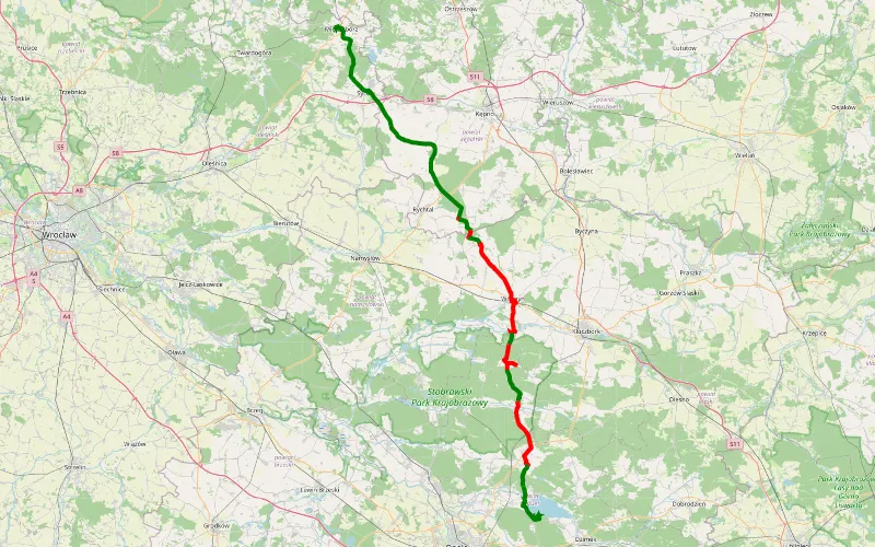
36% Offroad score
Easy
214m Highest peak
Międzybórz - Turawa
Offroad score36%
No known restrictions82%
Distance61.92 km
Highest peak214m
Offroad22.4 km
15 days ago
View route
73% Offroad score
Difficult
920m Highest peak
Ochota → Głuszyca Górna
Offroad score73%
No known restrictions69%
Distance415.12 km
Highest peak920m
Offroad303.47 km
11 months ago
View route
73% Offroad score
Difficult
920m Highest peak
Ochota → Głuszyca Górna
Offroad score73%
No known restrictions69%
Distance415.12 km
Highest peak920m
Offroad303.47 km
11 months ago
View route
100% Offroad score
Difficult
171m Highest peak
Bolesławiec - Siemianice
Offroad score100%
No known restrictions99%
Distance3.66 km
Highest peak171m
Offroad3.66 km
7 years ago
View route
76% Offroad score
Difficult
248m Highest peak
Weronikopole - Marcinki
Offroad score76%
No known restrictions65%
Distance7.04 km
Highest peak248m
Offroad5.33 km
7 years ago
View route
13% Offroad score
Easy
225m Highest peak
Retkinia Zachód-Smulsko - Skomlin
Offroad score13%
No known restrictions93%
Distance331.88 km
Highest peak225m
Offroad44.37 km
3 years ago
View route