



Routes
Nowe Miasto County/ Warmian-Masurian Voivodeship
Showing 23 routes

80% Offroad score
Difficult
162m Highest peak
Jamielnik - Nowe Miasto Lubawskie
Offroad score80%
No known restrictions97%
Distance25.24 km
Highest peak162m
Offroad20.24 km
3 years ago
View route
66% Offroad score
Moderate
167m Highest peak
Wielki Głęboczek - Mały Głęboczek
Offroad score66%
No known restrictions72%
Distance35.34 km
Highest peak167m
Offroad23.3 km
1 year ago
View route
64% Offroad score
Moderate
117m Highest peak
Jamielnik - Bagno
Offroad score64%
No known restrictions83%
Distance16.97 km
Highest peak117m
Offroad10.8 km
3 years ago
View route
44% Offroad score
Moderate
159m Highest peak
Kąciki - Wielki Głęboczek
Offroad score44%
No known restrictions80%
Distance64.99 km
Highest peak159m
Offroad28.83 km
4 years ago
View route
73% Offroad score
Difficult
124m Highest peak
Wielki Głęboczek
Offroad score73%
No known restrictions61%
Distance16.18 km
Highest peak124m
Offroad11.75 km
2 years ago
View route
31% Offroad score
Easy
225m Highest peak
Nowy Dwór - Nowa Wieś
Offroad score31%
No known restrictions98%
Distance55.38 km
Highest peak225m
Offroad17.43 km
4 years ago
View route
66% Offroad score
Moderate
127m Highest peak
Wielki Głęboczek - Nielbark
Offroad score66%
No known restrictions61%
Distance14.37 km
Highest peak127m
Offroad9.55 km
1 year ago
View route
35% Offroad score
Easy
237m Highest peak
Bachotek - Szałkowo
Offroad score35%
No known restrictions83%
Distance58.87 km
Highest peak237m
Offroad20.56 km
4 years ago
View route
74% Offroad score
Difficult
105m Highest peak
Mały Głęboczek
Offroad score74%
No known restrictions65%
Distance14.38 km
Highest peak105m
Offroad10.61 km
3 years ago
View route
100% Offroad score
Difficult
149m Highest peak
Nowe Miasto Lubawskie - Nowa Wieś
Offroad score100%
No known restrictions95%
Distance3.45 km
Highest peak149m
Offroad3.45 km
1 year ago
View route
80% Offroad score
Difficult
123m Highest peak
Bachotek - Otręba
Offroad score80%
No known restrictions23%
Distance12.97 km
Highest peak123m
Offroad10.36 km
2 years ago
View route
76% Offroad score
Difficult
113m Highest peak
Otręba - Iława
Offroad score76%
No known restrictions30%
Distance17.3 km
Highest peak113m
Offroad13.1 km
3 years ago
View route
77% Offroad score
Difficult
175m Highest peak
Kurzętnik - Iława
Offroad score77%
No known restrictions93%
Distance23.03 km
Highest peak175m
Offroad17.74 km
8 years ago
View route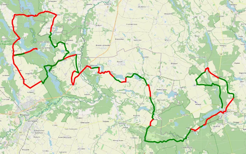
43% Offroad score
Moderate
164m Highest peak
Lidzbark - Bachotek
Offroad score43%
No known restrictions84%
Distance105.23 km
Highest peak164m
Offroad45.75 km
5 years ago
View route
59% Offroad score
Moderate
167m Highest peak
Zbiczno - Dąbrówno
Offroad score59%
No known restrictions95%
Distance60.6 km
Highest peak167m
Offroad35.6 km
3 years ago
View route
60% Offroad score
Moderate
174m Highest peak
Track gpx 2025-10-03 13:28
Offroad score60%
No known restrictions76%
Distance228.47 km
Highest peak174m
Offroad136.14 km
1 year ago
View route
42% Offroad score
Moderate
147m Highest peak
Brodnica turystyk
Offroad score42%
No known restrictions78%
Distance63.58 km
Highest peak147m
Offroad26.91 km
9 years ago
View route
36% Offroad score
Easy
246m Highest peak
Mazury. Maj 2026
Offroad score36%
No known restrictions85%
Distance659.24 km
Highest peak246m
Offroad237.15 km
5 months ago
View route
48% Offroad score
Moderate
164m Highest peak
Janówko - Samborowo
Offroad score48%
No known restrictions61%
Distance85.86 km
Highest peak164m
Offroad40.94 km
3 years ago
View route
29% Offroad score
Easy
219m Highest peak
Mały Głęboczek - Grunwald
Offroad score29%
No known restrictions80%
Distance198.22 km
Highest peak219m
Offroad56.68 km
3 years ago
View route
59% Offroad score
Moderate
170m Highest peak
Brodnica - Dąbrówno
Offroad score59%
No known restrictions91%
Distance114.35 km
Highest peak170m
Offroad67.36 km
8 years ago
View route
47% Offroad score
Moderate
259m Highest peak
Masuren 1
Offroad score47%
No known restrictions94%
Distance131.43 km
Highest peak259m
Offroad61.21 km
7 years ago
View route
46% Offroad score
Moderate
206m Highest peak
Bachotek - Ostaszewo
Offroad score46%
No known restrictions89%
Distance132.65 km
Highest peak206m
Offroad61.1 km
7 years ago
View route