



Routes
Wodzisław County/ Silesian Voivodeship
Showing 24 routes

100% Offroad score
Difficult
450m Highest peak
Buków - Lądek-Zdrój
Offroad score100%
No known restrictions99%
Distance9.27 km
Highest peak450m
Offroad9.27 km
2 months ago
View route
87% Offroad score
Difficult
194m Highest peak
Polder
Offroad score87%
No known restrictions96%
Distance8.29 km
Highest peak194m
Offroad7.18 km
9 months ago
View route
74% Offroad score
Difficult
197m Highest peak
Pogwizdów - Roszków
Offroad score74%
No known restrictions89%
Distance25.62 km
Highest peak197m
Offroad18.94 km
3 years ago
View route
52% Offroad score
Moderate
296m Highest peak
Mszana - Wilchwa nadal przejezdna (nocą).
Offroad score52%
No known restrictions81%
Distance26.98 km
Highest peak296m
Offroad13.9 km
1 year ago
View route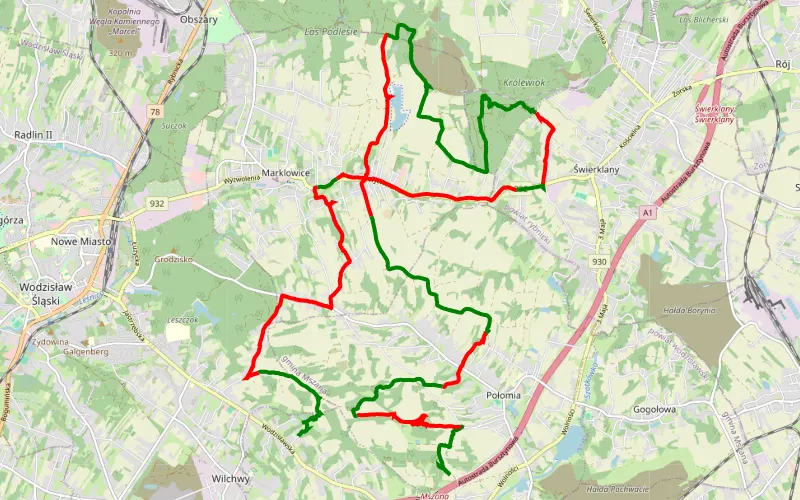
55% Offroad score
Moderate
460m Highest peak
Mszana - Wilchwa
Offroad score55%
No known restrictions81%
Distance30.59 km
Highest peak460m
Offroad16.68 km
4 years ago
View route
65% Offroad score
Moderate
194m Highest peak
Pogwizdów - Odra
Offroad score65%
No known restrictions93%
Distance20.4 km
Highest peak194m
Offroad13.26 km
3 years ago
View route
79% Offroad score
Difficult
284m Highest peak
Mszana - Markłowice
Offroad score79%
No known restrictions86%
Distance13.85 km
Highest peak284m
Offroad10.91 km
3 years ago
View route
71% Offroad score
Difficult
319m Highest peak
Wilchwa - Połomia
Offroad score71%
No known restrictions85%
Distance11.92 km
Highest peak319m
Offroad8.42 km
4 years ago
View route
47% Offroad score
Moderate
303m Highest peak
Mszana - Połomia
Offroad score47%
No known restrictions81%
Distance31.64 km
Highest peak303m
Offroad14.77 km
2 years ago
View route
100% Offroad score
Difficult
202m Highest peak
Bluszczów - Grabówka
Offroad score100%
No known restrictions99%
Distance4.64 km
Highest peak202m
Offroad4.64 km
1 year ago
View route
73% Offroad score
Difficult
287m Highest peak
Połomia - Markłowice
Offroad score73%
No known restrictions74%
Distance14.79 km
Highest peak287m
Offroad10.83 km
4 years ago
View route
75% Offroad score
Difficult
290m Highest peak
Mszana - Markłowice
Offroad score75%
No known restrictions72%
Distance16.88 km
Highest peak290m
Offroad12.72 km
2 years ago
View route
100% Offroad score
Difficult
287m Highest peak
Jankowice Rybnickie
Offroad score100%
No known restrictions72%
Distance4.39 km
Highest peak287m
Offroad4.39 km
1 year ago
View route
100% Offroad score
Difficult
191m Highest peak
Odra - Kamień nad Odrą
Offroad score100%
No known restrictions99%
Distance3.24 km
Highest peak191m
Offroad3.24 km
1 year ago
View route
87% Offroad score
Difficult
285m Highest peak
Mszana - Połomia
Offroad score87%
No known restrictions67%
Distance6.2 km
Highest peak285m
Offroad5.4 km
4 years ago
View route
100% Offroad score
Difficult
299m Highest peak
Jankowice Rybnickie
Offroad score100%
No known restrictions55%
Distance12.18 km
Highest peak299m
Offroad12.18 km
4 years ago
View route
81% Offroad score
Difficult
288m Highest peak
Gabrielówka - Jedłownik
Offroad score81%
No known restrictions92%
Distance7.84 km
Highest peak288m
Offroad6.31 km
4 years ago
View route
54% Offroad score
Moderate
289m Highest peak
Mszana - Wilchwa
Offroad score54%
No known restrictions82%
Distance34.06 km
Highest peak289m
Offroad18.52 km
4 years ago
View route
76% Offroad score
Difficult
283m Highest peak
Mszana - Jankowice Rybnickie
Offroad score76%
No known restrictions76%
Distance12.24 km
Highest peak283m
Offroad9.29 km
4 years ago
View route
38% Offroad score
Easy
328m Highest peak
Połomia - Młyny
Offroad score38%
No known restrictions84%
Distance67.97 km
Highest peak328m
Offroad25.5 km
4 years ago
View route
29% Offroad score
Easy
218m Highest peak
Skrzyszów - Krzyżkowice
Offroad score29%
No known restrictions98%
Distance14.74 km
Highest peak218m
Offroad4.28 km
4 years ago
View route
72% Offroad score
Difficult
281m Highest peak
Skrzyszów - Mszana
Offroad score72%
No known restrictions75%
Distance4.95 km
Highest peak281m
Offroad3.54 km
4 years ago
View route
68% Offroad score
Moderate
193m Highest peak
trasa2
Offroad score68%
No known restrictions97%
Distance29.19 km
Highest peak193m
Offroad19.76 km
8 years ago
View route
78% Offroad score
Difficult
263m Highest peak
wluczenge
Offroad score78%
No known restrictions91%
Distance53.01 km
Highest peak263m
Offroad41.51 km
8 years ago
View route