



Routes
Zwoleń County/ Masovian Voivodeship
Showing 23 routes

30% Offroad score
Easy
189m Highest peak
Sucha - Męcmierz
Offroad score30%
No known restrictions90%
Distance41.6 km
Highest peak189m
Offroad12.48 km
4 months ago
View route
87% Offroad score
Difficult
181m Highest peak
Wkoło Dębniaka
Offroad score87%
No known restrictions99%
Distance14.82 km
Highest peak181m
Offroad12.95 km
2 years ago
View route
83% Offroad score
Difficult
183m Highest peak
Niedarczów Górny - Kolonia Niedarczów Górny
Offroad score83%
No known restrictions98%
Distance10.55 km
Highest peak183m
Offroad8.8 km
3 years ago
View route
87% Offroad score
Difficult
214m Highest peak
Trasa hopsasa
Offroad score87%
No known restrictions81%
Distance15.38 km
Highest peak214m
Offroad13.36 km
2 years ago
View route
36% Offroad score
Easy
174m Highest peak
Janowiec - Przedmieście Kłudzie
Offroad score36%
No known restrictions99%
Distance17.85 km
Highest peak174m
Offroad6.41 km
1 year ago
View route
45% Offroad score
Moderate
197m Highest peak
Zajączków - Podolszyny
Offroad score45%
No known restrictions94%
Distance17.37 km
Highest peak197m
Offroad7.89 km
3 years ago
View route
40% Offroad score
Moderate
190m Highest peak
Florianów - Rajec Szlacheckiddddd
Offroad score40%
No known restrictions82%
Distance50.7 km
Highest peak190m
Offroad20.41 km
1 year ago
View route
78% Offroad score
Difficult
174m Highest peak
Trasa
Offroad score78%
No known restrictions99%
Distance21.07 km
Highest peak174m
Offroad16.42 km
7 years ago
View route
36% Offroad score
Easy
205m Highest peak
Pola
Offroad score36%
No known restrictions99%
Distance18.11 km
Highest peak205m
Offroad6.46 km
5 years ago
View route
67% Offroad score
Moderate
180m Highest peak
Dębniak
Offroad score67%
No known restrictions99%
Distance22.32 km
Highest peak180m
Offroad14.86 km
6 years ago
View route
27% Offroad score
Easy
236m Highest peak
Wakacje 2022.2
Offroad score27%
No known restrictions97%
Distance137.66 km
Highest peak236m
Offroad37.79 km
4 years ago
View route
28% Offroad score
Easy
239m Highest peak
TET section Kazimierz Dolny
Offroad score28%
No known restrictions98%
Distance116.34 km
Highest peak239m
Offroad32.85 km
4 years ago
View route
16% Offroad score
Easy
212m Highest peak
Topienie Marzanny
Offroad score16%
No known restrictions94%
Distance78.33 km
Highest peak212m
Offroad12.9 km
1 year ago
View route
100% Offroad score
Difficult
115m Highest peak
Lucimia - Gniazdków
Offroad score100%
No known restrictions99%
Distance1.61 km
Highest peak115m
Offroad1.61 km
4 years ago
View route
14% Offroad score
Easy
219m Highest peak
Malenice - Męcmierz
Offroad score14%
No known restrictions97%
Distance76.36 km
Highest peak219m
Offroad10.77 km
1 year ago
View route
22% Offroad score
Easy
437m Highest peak
PLAN Podlasie dzień3 powrót
Offroad score22%
No known restrictions97%
Distance488.82 km
Highest peak437m
Offroad109.09 km
5 years ago
View route
30% Offroad score
Easy
194m Highest peak
Radom -Janowiec
Offroad score30%
No known restrictions87%
Distance90.34 km
Highest peak194m
Offroad26.73 km
6 years ago
View route
32% Offroad score
Easy
194m Highest peak
Kazimierówka - Garwolin
Offroad score32%
No known restrictions91%
Distance87.17 km
Highest peak194m
Offroad27.96 km
5 years ago
View route
13% Offroad score
Easy
244m Highest peak
Nowe - Góry
Offroad score13%
No known restrictions99%
Distance144.21 km
Highest peak244m
Offroad18.15 km
3 years ago
View route
100% Offroad score
Difficult
170m Highest peak
Pola cd
Offroad score100%
No known restrictions99%
Distance1.8 km
Highest peak170m
Offroad1.8 km
5 years ago
View route
100% Offroad score
Difficult
123m Highest peak
Kłonowiec Koracz - Zakrzówek
Offroad score100%
No known restrictions99%
Distance1.49 km
Highest peak123m
Offroad1.49 km
5 years ago
View route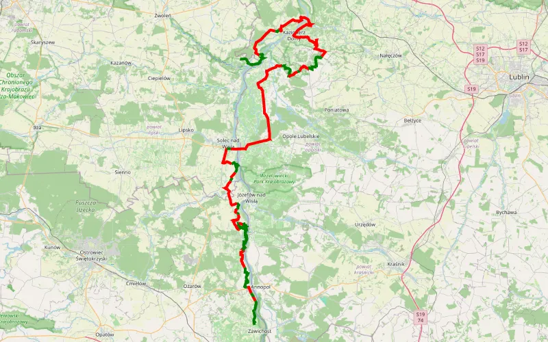
37% Offroad score
Easy
193m Highest peak
Tarnobrzeg - Dorotka - Kazimierz - Solec
Offroad score37%
No known restrictions98%
Distance151.89 km
Highest peak193m
Offroad55.83 km
8 years ago
View route
27% Offroad score
Easy
198m Highest peak
Sadków - Firlej
Offroad score27%
No known restrictions96%
Distance99.02 km
Highest peak198m
Offroad26.84 km
5 years ago
View route